Satellite monitoring. Part 1
Old tricks in a new way
Satellite monitoring of mobile objects thing is absolutely not new. For many years carriers, and fleets use GPS trackers to determine the location of each machine in the fleet. It is not difficult to learn not only the location of vehicle, but the amount of fuel consumption, speed, and any other information from sensors of the vehicle.
Still under satellite monitoring meant the device location via a global positioning system (GPS, GLONASS, Galileo, etc.) and data transmission via GPRS, at least on radio or Wi-Fi.
The main problem of existing systems is the lack of global coverage. Many companies have found a way to use "black box", the buffer in which to store information about points and transmitted as soon as network. But what if the data you need to constantly? And if the technique for many months is not included in the GSM network? In our practice had a client who once every two weeks to the object traveled a special person with a laptop and collecting data from trackers on Wi-Fi. The decision more than disputable.
Satellite network and M2M
The solution was found on the surface. More precisely above the surface. From 740 to 35,000 km above the earth. Installing trackers with satellite channel or satellite modems to support existing systems. At the moment, the two networks provide excellent coverage and support M2M services.
Iridium – the largest satellite network with 100% coverage of the Earth. 66 active satellites and 6 backup provide data from the most remote corners of the planet. Height of 740 km. the satellites At any point in time you could not be less than 3 satellites, which allows equipment to spend less time on the search beam.
Inmarsat is the second largest satellite network. Coverage is 98% and is secured by 11 geostationary satellites. However, data transfer requires guidance to satellite or, in the case of using Omni-directional antennas, line of sight of the satellite, that is to the South.
The picture would not be complete if I fail to mention operator Thuraya, the youngest of them all. Satellites operator in the same geostationary orbit. The coating is much inferior to the previous two, but due to price traffic like voice and IP. In addition, the company has released a module all-in-one enables you to create your device. In addition, the module heavily bribing the low price.
In the first part we'll look at equipment for data transfer in the Iridium network.
Hardware
The company Iridium has an extremely controversial past. On the one hand is the largest satellite network, with another — the experienced bankruptcy in 1999 resulted in a shutdown of all network devices. However, in 2001 the company was re-launched. Guide heavily revised pricing policy. Now transfer data and voice costs reasonable money (a minute of conversation before 1999 – 5$/min, at the moment, to 1.2$/min). Satellite phone costs a little more than 1000$, which is quite acceptable in our time.
However, not only the phones will be discussed. In the company's portfolio appeared embedded modules that can be used for integration into existing devices and to create your own data devices.
Modules are of two types: SBD module and the module with support for all company services.
The most interesting for us is the first type, specifically the Iridium 9602 module manufacturing company Nal Research.
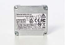
The 9602 module is used only for transmission of SBD traffic, which has beneficial effects on its cost ($300).
SBD (Short Bust Data) – the type of traffic used to transmit short messages. A long message can be up to 1920 bytes, but more often there are messages up to 340 bytes. Data may be transmitted by e-mail, IP, IMEI of other SBD device.
Located on the module: input Iridium antenna input GPS antenna (not a very clear purpose. In your device we don't use it), 20 pin connector.
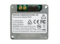
To transmit information to the module used by RS-232 port.
the Principle of data transmission
In the vehicle monitoring system the main transmitter is a GSM module and backup module via the Iridium 9602. The route of the data packet transmitted via GPRS is extremely simple. The tracker collects point data (coordinates, speed, fuel, etc.), compresses them according to its Protocol and sends it to the IP of the monitoring server. However, the data compression Protocol for cellular networks is not suitable satellite channel. The fact that via GPRS messages about points are transmitted with high frequency. About twice per minute. For satellite this flow of traffic is an unacceptable luxury. In this regard, developed a special Protocol that collects data from several points, pack into a single message and sends to the server once the packet size reaches 340 bytes. As a result, we have two different format data from a single device. But not all developers monitoring systems are ready to support additional protocols in their software. We come to the aid decisions on emulation packages. Below, illustrates the route of the data packet from the device to the monitoring server.
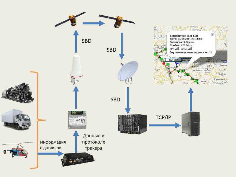
The tracker controller periodically polls the sensors and collects information in the package. Each survey period is the point and signed by GEODATA. As soon as the package reaches 340 bytes to the controller via the RS-232 port, sends data to the module, where they go in the SBD format. Since, at this point, the connection point (teleport) with just one, then the data is transmitted from the satellite to the satellite to a teleport, where the package is assigned an IP address and the destination port. For what would the server know where to send the data, check the device's IMEI must specify the IP address and port of our server emulations. In the system you can set up to 5 different destinations. Quality you can specify the e-mail, IP or IMEI of other SBD device (it may be necessary to implement a messaging system). After the emulation server has received the data, it unpacks the packet and packs each point separately emulating the Protocol in which the data is going over GPRS. Further information about the points is sent to the monitoring system and we can see the route and condition of transport at different stages of the movement.
Why do it
To have data on the movement of transport is nice, but not all companies see them as a favor. Really, why send data via satellite, if they can collect and send as soon as GSM network?
The most compelling argument is the ability to receive emergency information. Can burst the wheel, to occur the discharge of fuel, engine failure and a lot of unpredictable situations. In this case there is an extraordinary package and sent to the monitoring system, allowing you to take emergency measures. In the event of emergency situations not directly related to transportation may provide the emergency call button.
Other applications
For example, monitoring of transport can be understood that the 9602 module can be useful in any field where is necessary to obtain relevant information from remote sites or to provide a backup data transmission channel. Vending machines, life buoy, meters and other equipment that requires constant supervision. Low power mode allows you to create on the basis of the modem module to transfer data from points at which no permanent power supply. The simplest example sensors monitoring seismic activity.
Summary
Module 9602, like Iridium, is not the only solution for M2M. Under the decision of each task it is possible to select the necessary equipment and to select the most suitable operator. In following articles I will describe the modem Iridium 9522b and 9523 module, and talk about solutions based on operator Inmarsat, has long retained a monopoly on satellite transmission data in C and L bands in Russia. Will not do without attention and Thuraya, as well recently received a license to operate in Russia.


Комментарии
Отправить комментарий